Three Things Every G3/S3 Should Know About Geospatial Engineers
CW3 Frederick I. Dessau
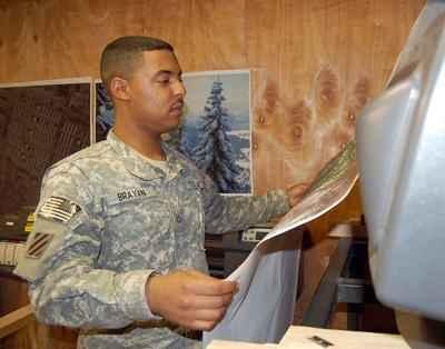
A geospatial analyst assigned to the 3rd Heavy Brigade Combat Team, 3rd Infantry Division, pulls a map off a plotter at a contingency operating site in Iraq, on 30 March 2010. (Photo by SPC Ben Hutto)
Sun Tzu devotes an entire chapter to understanding terrain in the classic military treatise The Art of War. Terrain matters because it’s a central element of any strategy, and no mission can succeed without knowledge of the terrain.
Today, knowledge of the terrain comes through geospatial analysis provided by a team of geospatial engineers. Crucial to the success of the military decision-making process (MDMP) and intelligence preparation of the battlefield (IPB), geospatial engineers enhance planning, support the priority intelligence requirements (PIRs) and commander’s critical information requirements (CCIRs), and more importantly, allow the commander to visualize the terrain. But often geospatial engineers are not integrated and synchronized into the planning process because the staff doesn’t understand what a geospatial engineer can do. As a result, our geospatial support lags far behind the technology.
Successful geospatial support doesn’t need to be that difficult. Geospatial support does not require that a staff officer is a subject matter expert (SME) on computer systems or software but on the fundamentals of good leadership. Simply put, a staff officer needs to only remember three things: Soldiers, products, and supplies. By understanding how these fit into geospatial support, a staff officer can ensure the success of geospatial engineers.
Soldiers
The Army‘s experts in the production of geospatial products, geospatial engineers are Soldiers trained to produce the products of most use in mission planning. Geospatial engineers (military occupational specialty [MOS] 12Y and warrant officer MOS 125D) extract geographic data from satellite imagery, aerial photography, and field reconnaissance to create and maintain multiple geospatial databases. This data is then compiled into maps, which help commanders visualize the battlefield. Also, a staff officer can prepare military-style briefs and reports. When Soldiers are on detail or being utilized outside of their MOS however, no geospatial analysis takes place. A geospatial engineering technician, while technically an engineer officer, is ill-used when not serving as an SME. Similarly, assigning a geospatial engineer as the CBRN (chemical, biological, radiological, nuclear) NCO, sergeant major’s driver, or perpetual gate guard, wastes the special training and expertise these Soldiers possess. Geospatial skills are perishable if not regularly used. Low-density training should be incorporated into sergeants’ time training, and leaders should take advantage of mobile training team opportunities and the Foundry Program. Esri, a mapping software firm, also provides online training to Soldiers for free. Challenging collective and individual training and validation exercises are essential to being ready and relevant.
Products
Products displaying operational graphics are always requested. There are, however, more powerful products geospatial engineers are trained to produce. These “standard products” include cross country mobility (CCM), and with the addition of other layers of information, a resulting combined obstacle overlay (COO). The G2/S2 can then use this COO, add relevant information, and produce the modified COO (MCOO). Adding multiple overlays results in a mobility corridors product. Similarly, a line-of-communication product identifies available road and transportation networks. Hydrology analysis shows the operational impacts of water sources. Drop zone and helicopter landing zone analysis locates and displays possible drop zones to support airborne operations and/or possible landing zones to support air assault operations. Vegetation analysis depicts the suitability of an area (such as cover and concealment, mobility restrictions) based on the effects of the vegetation, while soil trafficability shows the effects of soil on movement. An artillery slope tint product templates enemy artillery assets based on slope restrictions. Line-of-sight (LOS) analysis shows areas of direct observation from a given point that can help position LOS-based systems. These standard, basic products are the building blocks of geospatial support. This is only a start though. If it is related to the terrain, chances are it can be visualized and displayed on a geospatial product.
Supplies
Geospatial engineers currently utilize the Digital Topographic Support System (DTSS) to produce geospatial products but are increasingly using the Distributed Common Ground System-Army (DCGS-A), which is the Army’s primary system to post data, process information, and disseminate intelligence. Geospatial processing software programs, such as ArcMap, are used to view, edit, create, and analyze geospatial data. The systems have to be functioning properly and can’t work if there’s no data to process or any paper and ink to print. The National Geospatial Intelligence Agency (NGA) and the Army Geospatial Center (AGC) provide data free online as do other national agencies. Hard drives and disks can be ordered as well. Even before receipt of the mission, a geospatial team should be building a database of geospatial information. Similarly, updates to hardware and software, as well as security patches, are essential and should be completed prior to an exercise or deployment. The crucial beginning days of an exercise or deployment should not be spent on fixing broken equipment or installing new software. While the Army has gone digital, there remains a reliance (and some could argue preference) for paper maps. Simply put, paper maps require lots of paper. One 150-foot roll of paper doesn’t go very far when each commander and staff section wants a large wall map. Because the first product the geospatial team will produce are multiple versions of this big map. By keeping the map free of information that is likely to change, paper is saved. Paper and ink are essential because there’s not much of a workaround when the section runs out. If the supply section isn’t ordering paper regularly (it’s available through the supply system), geospatial production could grind to a halt. That’s why printing endless posters and PowerPoint slides wastes valuable resources and results in the geospatial team lacking the necessary supplies to complete its mission. Supervising these requests and developing a good standard operating procedure (SOP) describing priorities will help prevent much of this.
With integration of the Soldiers, creation of standard (and non-standard) products, and by providing the necessary tools and supplies, the geospatial team is a valuable tool in planning and operations. Successful geospatial support results in knowledge of the terrain, but understanding how geospatial assets support mission planning is key. Common sense and good management go a long way. Understanding how to lead and manage geospatial support will thus reap great results in planning as well as in visualizing the battlefield. It’s not so much about technology but leadership. By concentrating on the Soldiers who create the products and providing the tools necessary to complete the mission, results in geospatial support will seem effortless.
During 18 years of service, CW3 Frederick I. Dessau has served as a geospatial engineer at all echelons from company to brigade NCOIC to theater as well as joint and NATO assignments. CW3 Dessau supported the 1st Cavalry Division twice in Baghdad, Iraq, as the officer in charge of the Division Engineer Geospatial Cell. He has completed seven deployments including rotations to Haiti, the Balkans, Iraq, and NATO Support to the African Union in Addis Ababa, Ethiopia.
 Share on Facebook
 email
email print
print
Figure 1 — Bradley ECP 1 & 2 Technologies